News Summary
Residents of Myrtle Beach and Central South Carolina should prepare for gusty winds and showers as the National Weather Service issues alerts. Winds may reach up to 40 mph with the potential for thunderstorms and even a tornado watch in effect. Stay informed and secure your surroundings as conditions may lead to hazardous situations.
Weather Alert: Breezy Showers and Thunderstorms Hit Myrtle Beach!
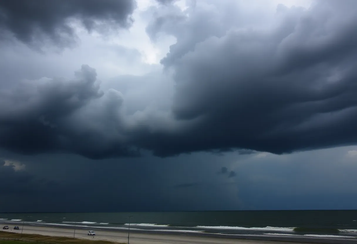
If you live in Myrtle Beach or Central South Carolina, it’s time to grab your umbrellas and hold onto your hats! The National Weather Service (NWS) has issued an updated weather report that highlights some gusty conditions expected in the area. The warning came through at precisely 12:01 p.m. on Sunday, and it’s essential to stay updated on what’s happening outside.
Expected Showers and Wind Gusts
For those in the Myrtle Beach area, *gusty showers* are anticipated to stick around until about 1:30 p.m. today. That means you might want to stay indoors for a bit if you can! Winds are expected to whip up to 40 mph, which could lead to some messy conditions. As of noon, Doppler radar was tracking showers stretching roughly from Shannon, moving east near Mullins, and reaching close to Hampton Plantation State Park. The overall movement of these showers is heading southeast at a quick pace of about 45 mph.
Keep Your Surroundings Safe
With winds this strong, it’s a good idea to be mindful of your surroundings. Strong gusts could very well knock down tree limbs or send unsecured items flying—so it’s best to secure anything that might blow away. The areas affected by today’s alert include:
- Myrtle Beach
- Lumberton
- Conway
- North Myrtle Beach
- Georgetown
- And several other neighborhoods and towns
Don’t forget that this alert also extends to parts of Interstate 95 in North Carolina, between mile markers 10 and 38. Stay alert if you’re on the road!
Severe Thunderstorm Watch In Effect
Attention, residents! A Severe Thunderstorm Watch is in place until 5 p.m. for southeastern North Carolina and northeastern South Carolina. If you are outdoors, it’s highly recommended to seek shelter inside a building. Pro Tip: If you run into flooded roads, don’t hesitate to make a U-turn. Flash floods can be deceptively strong, capable of carrying away vehicles and causing severe damage.
Understanding Hydroplaning
Make sure to keep the roads safe while driving. Hydroplaning can occur when a vehicle slides uncontrollably on wet roads due to water accumulation. This situation can lead to loss of control, and it is usually caused by a combination of water depth, speed, and tire conditions.
Strong Thunderstorm Alerts from Central South Carolina
Key areas affected include:
- Orangeburg
- Manning
- Brookdale
- And plenty more!
Highways like Interstate 26 and Interstate 95 are also included in this alert, so drive safely if you’re in these regions.
A Tornado Watch? Yes, You Heard Right!
As if that wasn’t enough, a Tornado Watch is in effect until 1 p.m. for central South Carolina. With the summer months being notorious for electrical storms, remember that lightning strikes the U.S. approximately 25 million times every year—most often during this season. The risk of lightning heightens significantly as a storm approaches, peaking when it is directly overhead.
So, whether you’re cozying up at home, planning your afternoon activities, or driving around town, stay vigilant and ready to take action when needed. This weather won’t last forever, but for now, keeping safety in mind is the best strategy!
Deeper Dive: News & Info About This Topic
HERE Resources
Myrtle Beach Prepares for Main Street Upgrades
Tornado Devastation in Alvin Claims Life and Leaves Family Heartbroken
Storms Devastate Athens, Alabama, Leaving Communities in Ruins
Severe Weather Threat Looms Over Charlotte as Storms Expected this Sunday
Severe Thunderstorms Expected in South Carolina Today; Residents Urged to Take Precautions
Cultural Event in Sumter Highlights Native American Heritage and Urges Recognition of Indigenous Rights
Five Tornadoes Strike Houston Area Just After Christmas
Tropical Storm Helene Approaches Florida Coast
Thunderstorms on the Horizon: East Texas, Louisiana, and Arkansas Brace for Impact!
Golf Courses Leading the Charge in Water Conservation During Drought
Additional Resources
- Myrtle Beach Online: Weather Alert
- Wikipedia: Weather Alert
- Myrtle Beach Online: Storm Warning
- Google Search: Severe Thunderstorm Watch
- WMBF News: Cold Weather Alert
- Google Scholar: Weather Conditions Myrtle Beach
- Herald Online: Thunderstorm Update
- Encyclopedia Britannica: Thunderstorm
- Myrtle Beach Online: Weather Advisory
- Google News: Myrtle Beach Weather Alerts

Author: STAFF HERE MYRTLE BEACH
The HERE Myrtle Beach Staff Writers are a collaborative team of journalists, editors, and local contributors passionate about delivering accurate, timely information to the Myrtle Beach community. As part of the HEREcity.com Network, which powers over 100 U.S. city sites including HEREcolumbia.com, our staff draws on collective experience in South Carolina journalism to cover everything from business sales and real estate developments to dining deals and community initiatives. Our Expertise and Background Local Roots in Myrtle Beach Our team includes lifelong Myrtle Beach residents and SC natives with deep knowledge of the area’s history, economy, and culture. We’ve covered key events like the recent developments along the Grand Strand, Myrtle Beach’s tourism and hospitality industry, and growth in local education sectors (e.g., Coastal Carolina University programs). Collective Experience With over 50 combined years in journalism, our staff has backgrounds in print, digital media, and community reporting. We prioritize fact-based stories, drawing from sources like the Myrtle Beach Area Chamber of Commerce, city government records, and on-the-ground interviews. Commitment to Quality Every article is a group effort, involving research, editing, and verification to ensure reliability. We adhere to journalistic standards, citing credible sources and updating content as new details emerge.