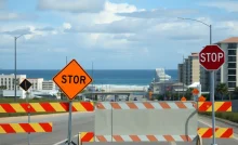

Storm preparations in progress
Hey Myrtle Beach! It looks like we’re gearing up for some serious storm action as Hurricane Helene has made its way into the Gulf of Mexico, heading our way. As of 11 p.m. Wednesday, this Category 1 hurricane is packing sustained winds of 85 mph and is moving north at about 9 mph. Tropical storm warnings have been issued for our entire state, so let’s get ready and stay safe!
Helene isn’t just sitting pretty. The forecast says it could quickly ramp up to a major hurricane by Thursday. We’re talking about a potential increase in wind speed by a whopping 50 mph in just 24 hours. Yikes! It looks like the storm will be moving north before it changes course, heading towards the Florida Panhandle and making landfall near Panama City or Tallahassee as a strong Category 4 hurricane with gusts hitting 130 mph.
While we won’t get the brunt of it, there are a few things we should keep in mind:
There’s a 15% chance of isolated flash flooding in our neck of the woods, while the Upstate might see a higher risk at about 70%. If you’re venturing out, be cautious and avoid driving through flooded areas!
With the storm surge expected and the onshore flow of water, coastal flooding could affect our area too. Always be alert to changing conditions and any advisories that pop up.
After Hurricane Helene, it looks like there’s another weather disturbance brewing off the coast of Africa. This one has a solid 80% chance of developing into a storm in the coming weeks, potentially named Isaac. Luckily, current models are keeping it out to sea, so that’s some relief!
Now is the time to secure those loose items around your home and make sure you have enough supplies. Stock up on water, non-perishable snacks, and something fun to binge-watch just in case you get stuck inside for a while!
As always, stay tuned for updates and listen to any evacuation orders or safety recommendations. Myrtle Beach has weathered storms before, and we’ll get through this one too. Stay safe out there!
News Summary Michelin North America Inc. proudly marks its 50th anniversary in South Carolina, highlighting…
News Summary Vice President JD Vance visited the Nucor Steel plant in Huger, South Carolina,…
News Summary The University of South Carolina's International MBA program has been ranked as the…
News Summary Huntington National Bank has officially opened its first branch in South Carolina, located…
News Summary Rep. Hamilton Grant has introduced the 'Small Business Construction Impact Relief Act' to…
News Summary Myrtle Beach is experiencing a surge in its beachwear market with 56 shops…